Many people travel to explore new cities and ancient monuments, while others wish to embrace dynamic horizons where not a single man-made structure is in sight.
This world, created 4.5 billion years ago, is a treasure trove of nature's creativity displayed in some of the most spectacular visions you can imagine, and some defy the wildest imagination. Sinkholes of a myriad of bright colors, volcanoes that have erupted over eons to create a woven tapestry of molten lava rivers of residue, waterfalls towering in the sky with turbulent cascades, subterranean caves with a jumble of delicate stalagmites and stalactites, beaches cloaked in black sand; and the list goes on of unbelievable visions.
The earth is a fairytale of other-worldly landscapes that inspire flights of imagination, such as the ones below:
Vermilion Cliffs, Arizona
Rock formations like no other, the Vermillion Cliffs run the length of 48 kilometers with a height ranging between 2,000 and 3,000 feet. Their massive presence is south of the Utah state line in the United States and can be seen when you drive along Highway 89A. They are a part of the Grand Staircase of the Colorado Plateau in north Arizona, extending into both Utah and Arizona. Once an essential route for settlers from Utah to Arizona in the 19th Century, today's highway follows the old wagon route, passing through House Rock Valley up through the Kaibab Plateau to arrive at Jacob Lake. This northwest enclave of Arizona is separated from the rest of the state by the Colorado River and the Grand Canyon.
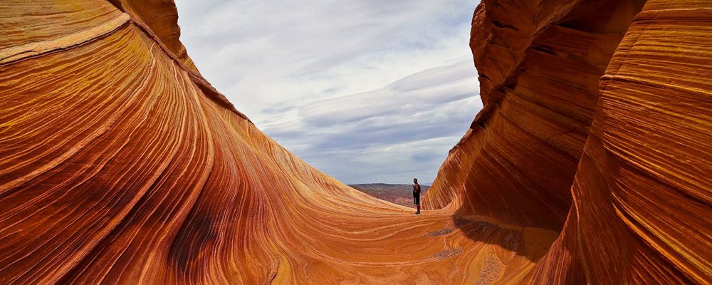
Like syrup stirred into ice cream, their swirling hues of red and orange create twists and curlicues as if an artist had painted them with an uneven brush to create a pattern like no other. Mammoth rock formations have exploded from being earthbound, meandering canyons run like veins through its earthly body, and arches appear like ancient stone carvings by giants. Formed by long years of erosion, sedimentation, and the upward shuffling of the earth, the Vermillion Cliffs' abrupt exposure in almost perpendicular escarpments showcases layer upon layer of sedimentary rocks such as siltstone, shale, sandstone, and shale.
Other famous sights in this area include The Wave with its fragile undulating forms, Coyote Buttes where you will find the footprints of dinosaurs, Lee's Ferry, which was the site of a ferry crossing in the 19th Century, Glen Canyon and The Glen Canyon National Recreation Area, and more. You must have permits to hike and/or camp to see this landscape. It's strenuous trekking—not for the unfit—with campers required to take everything they need for an overnight camp and bring it back out again. But, sleeping under an endless vision of stars in an ink-black sky amidst rocky desert formations that reach for the heavens would make it the trip of a lifetime.
Salar de Uyuni, Bolivia
Salar de Uyuni is one of the most spectacular sights on the planet. It's the largest natural salt flat in the world, where pink flamingos dance in their age-old ritual upon a crystal surface. Born from the drying up of a prehistoric lake that left a desert-like landscape of rocky formations, cacti-studded islands, and brilliant white salt, Salar de Uyuni covers over 10,000 square kilometers with Isla Incahuasi, a stark gem amidst the whiteness. This island's name, when translated from the native Quechua language, means 'house of the Inca'. Perched on top of what was an ancient volcano that was partially submerged into the giant prehistoric lake, coral surrounds its shores, and the ground is smothered in giant cacti, many more than two meters high, which is a dynamic contrast to the surrounding salt pan. Today, there's a café on this anomaly for hikers drawn for the best view over the salt flats.
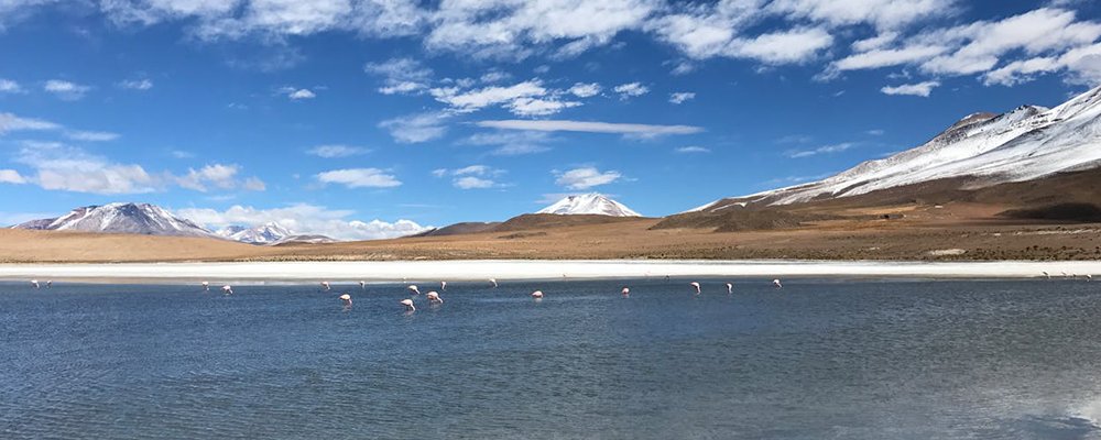
The world's largest natural mirror, Salar de Uyuni, can be seen from space. The rainy season (December to April) brings sparkling clear water, giving the salt flats their breathtaking mirror surface, while during the dry season (May to November), the surface morphs under perfectly clear blue skies into astounding hexagonal patterns. Holding half of the world's lithium reserves, it is so flat that it's used to calibrate satellites.
Watch the movie Star Wars, Episode VIII, The Last Jedi (2017) for a cheat peek at this unique site.
The Eye of the Sahara, Mauritania
Another awesome landscape that can be seen from space is the Eye of the Sahara, also known as the Richat Structure, sitting near Ouadane in the Adrar region of Mauritania on the Atlantic Coast of northwest Africa. This surreal specter appears like a giant bullseye with surrounding rings and ridges. At one time, it was believed to be the lost city of Atlantis. Another time, it was considered a massive impact crater, then an eroded dome; from space, it looks like a fossilized ammonite—an extinct coiled-shelled creature. This curiosity dates back to when the earth was so hot that it became liquid rock that, when cooled, it became a crystalline structure resembling a human eye.
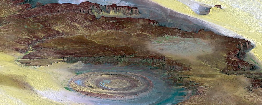
Eroded over time by wind and rain sculpting it into what we see today, it’s a visible record of millions of years of geological history, a 40-kilometer wide aberration like a battle scar on the earth’s surface where an amazing collection of stone tools from 1.7 million years ago have been found. Because of its sheer size and remoteness, it was first discovered by astronauts McDivitt and White when on the Gemini 4 mission in 1965.
Apart from going into space to see this marvel, you can take hot air balloon or airplane tours over the Eye to get an eagle eye perspective.
Gail Palethorpe, a self proclaimed Australian gypsy, is a freelance writer, photographer and eternal traveller. Check out her website Gail Palethorpe Photography and her Shutterstock profile.